The other day’s inaugural run along the TET’s Great Western Trail in Dorset was unnervingly easy and enjoyable. I wasn’t wrong footed and barely put a foot wrong. Today’s westward continuation was going to be my difficult second album. For more afteride bike impressions, see bottom of the page.
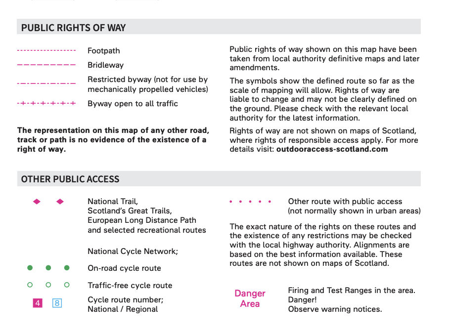
Rights of Way (skip if boring – E&OE) The last time I looked into it, to establish the status of a right of way in England & Wales (Scotland is a write-off) you had to inspect a county council’s definitive or ‘master’ map (DM) held in its offices and viewable by appointment. This is why people ride wasteland, join clubs or go to Morocco. Now we have the internet county councils publish this map online for all to view anytime for free. Vehicle access wise, the map will identify the very few Byways (aka BOATs), as well as much more numerous Unclassified Country Roads, (UCRs) which I calledORPAs (‘other routes with public access‘, on OS maps). But according to this typical statement, the Dorset Definitive online map (example below) doesn’t have the legal status of the county’s official Definitive Map held in a glass vault in Dorchester Castle. So while you cannot fully rely on the online county master map, it ought to be more up to date than the latest OS edition and is free. Perhaps the best online map for trail biking is produced and maintained by the Trail Riding Fellowship. It’s viewable at greenroadmap.org.uk where it says guests (non-TRF members) can register and view the map with limited features, but I couldn’t manage it. This is why we like the simplicity of UK TET with the GWT. One 3800-mile gpx download and you have enough to be getting on with.
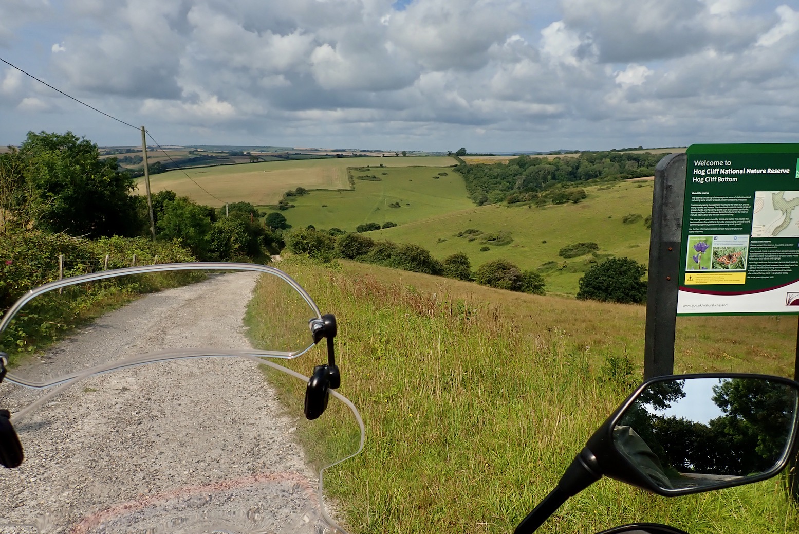
Only one Byway in red, but quite a few ‘UCRs’ in light and dark blue, some of which join through.
These UCRs or ORPAs – shown on OS maps as small red spaced dots on 50k maps • • • • , or green on 25k • • • • – have been a bit of an eye opener to me just lately, still stuck as I am in the 1980s RUPP era, but ORPAs have been on OS maps since 1997 and RUPPs were downgraded or mass reclassified as Restricted Byways by 2006. All this has passed me by over the decades. Clearly I’ve spent too much time in the desert where, by and large, an RoW is determined by the terrain and you and your vehicle’s ability to navigate it.
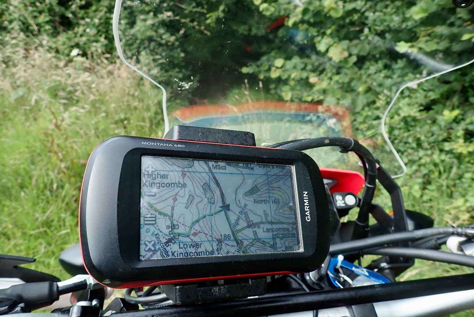
UCRs might be sealed or just tracks, passable or otherwise, but providing they don’t dead end at some backwoods ‘dueling banjo’ meths compound (as I stumbled on the other day), you have the promise of a through route. So I can now verify that track I followed in mid-Wales the other week was a UCR and doesn’t even get any special annotation to the Powys Definitive online map. As DK and DW, a pair of intrepid travel bikers and TRF lifers clarified to me “In 99% of cases, you can legally ride a bike on a UCR“. When you view the Dorset GWT on an OS background, you can see it aligns with UCRs and the much less frequent Byways as well as regular metalled yellow ‘C’ roads.
An ORPA or UCR in DorsetMid-Wales kosher!
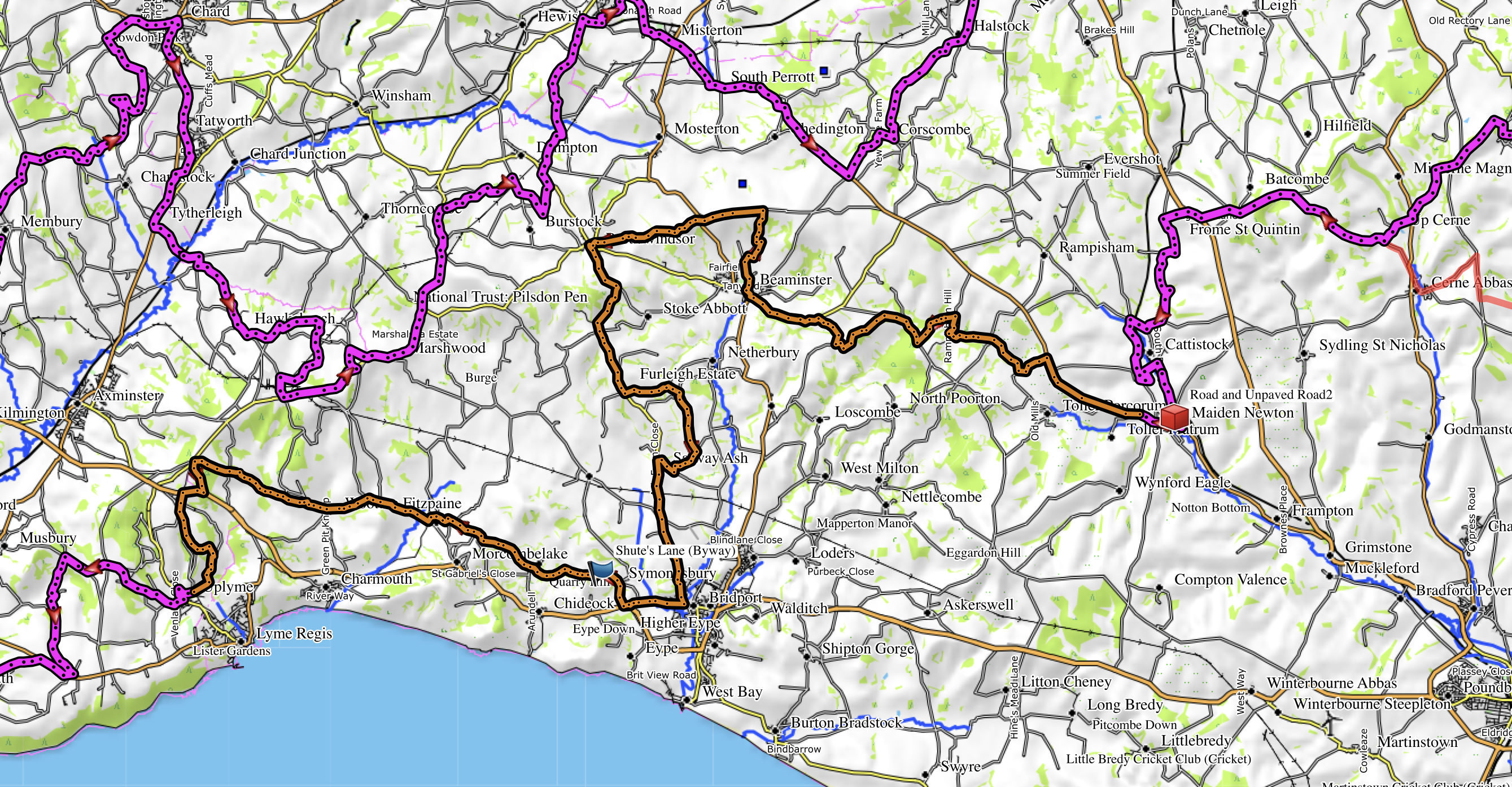
The TET gets offensive The forecast was a bit shaky; I’d probably get a hose-down at some stage but would dry off eventually, given global climate patterns. I was planning on reaching Lyme Regis, about the same distance as the other day, though something about today’s route looked more challenging and maybe more typical of the GWT.
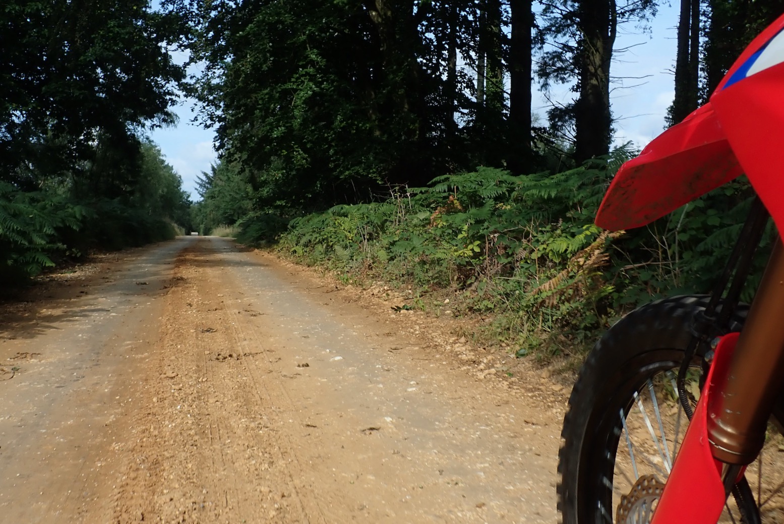
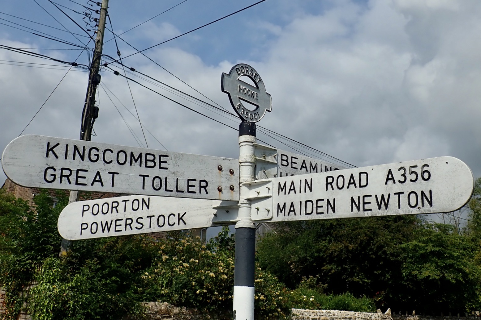
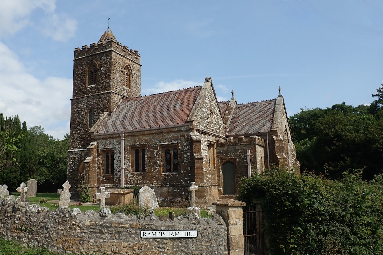
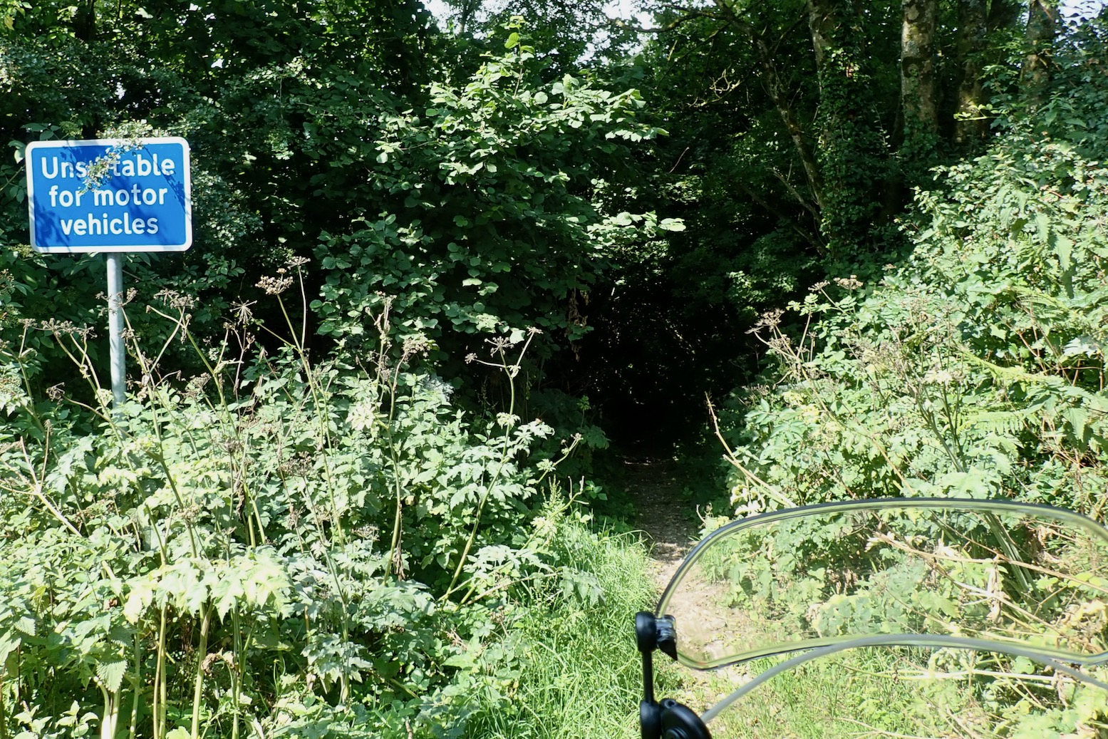
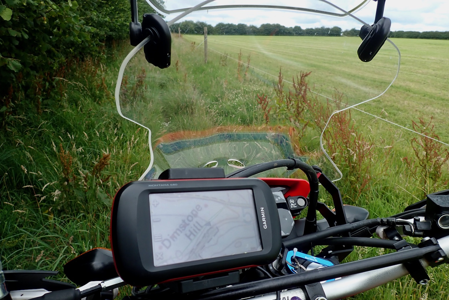
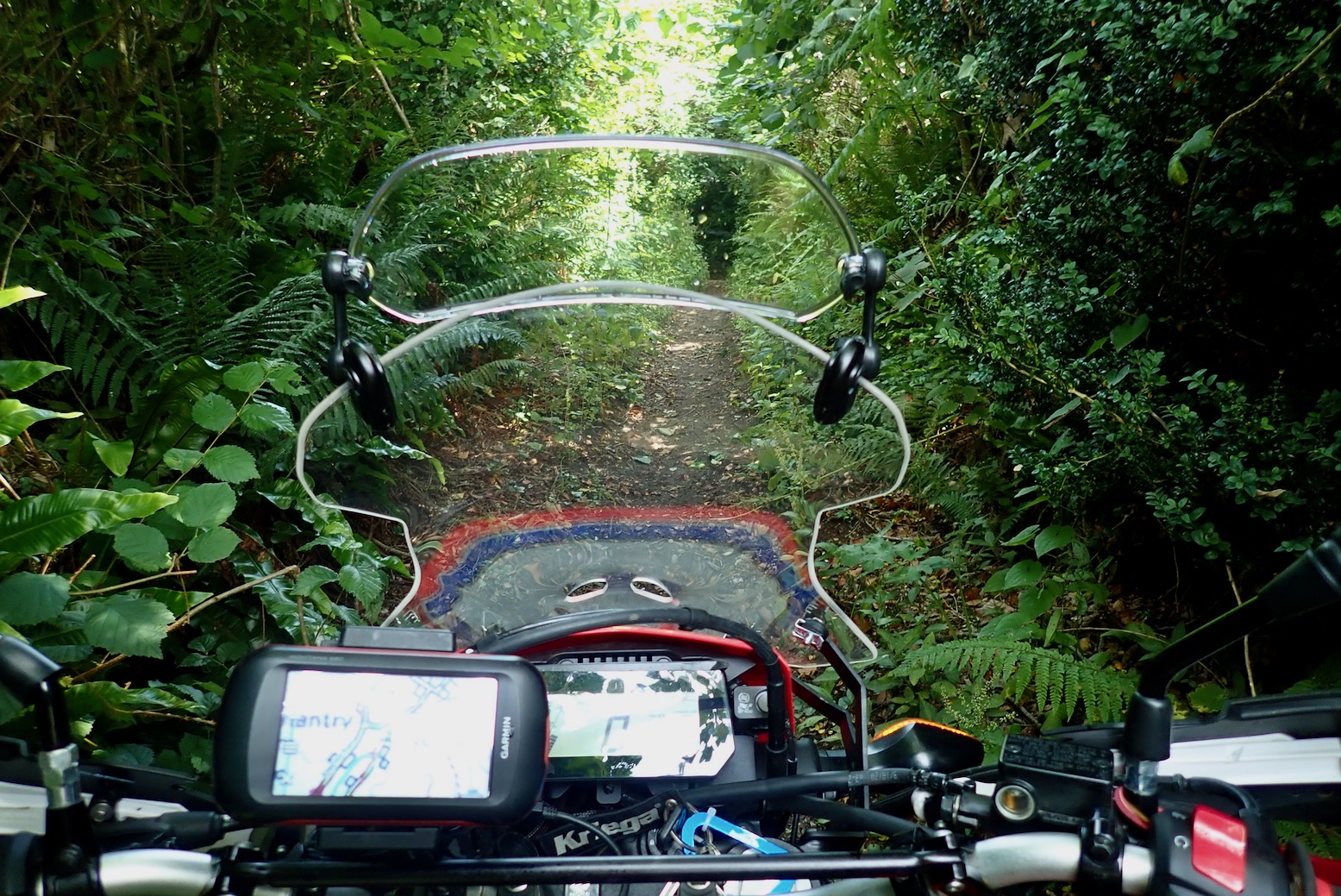
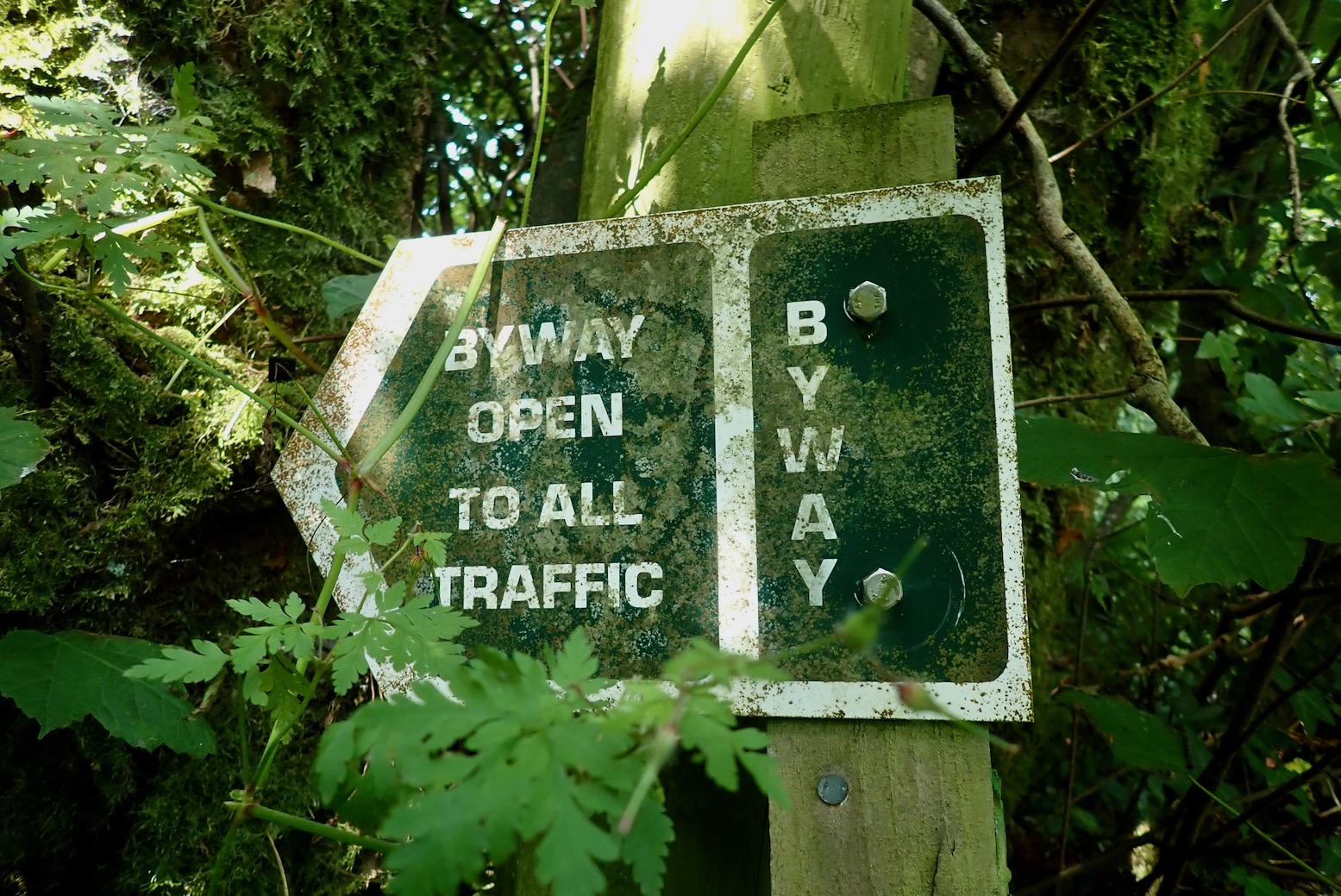
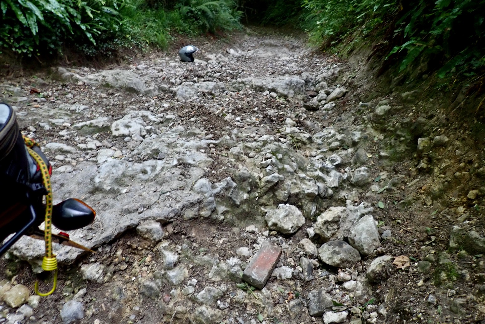
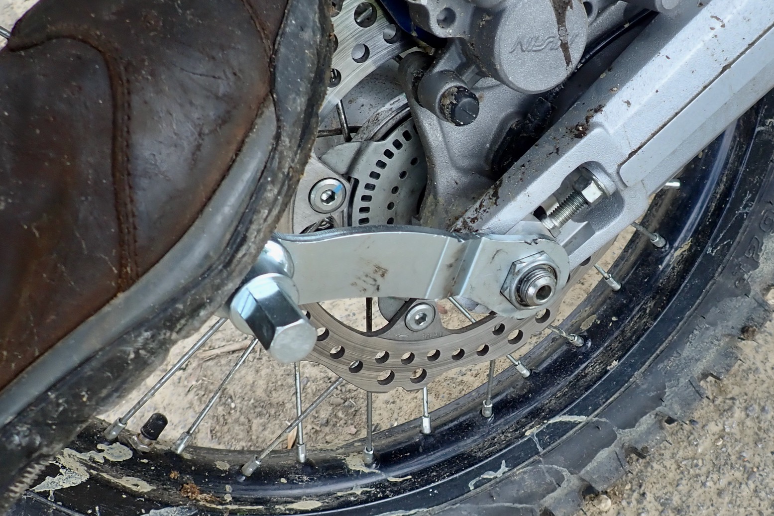
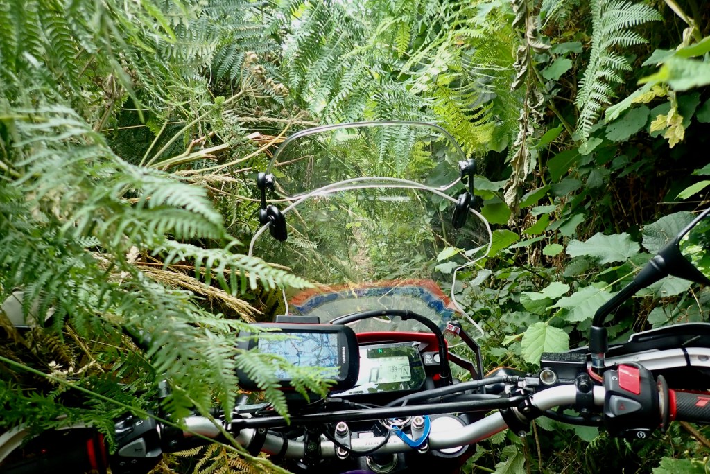
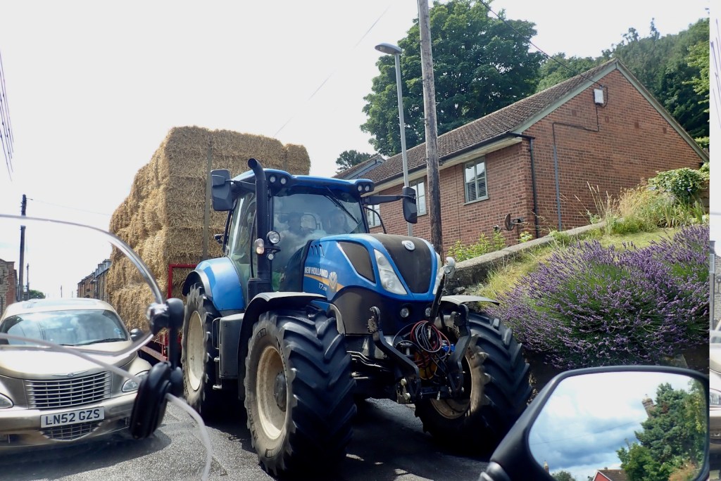
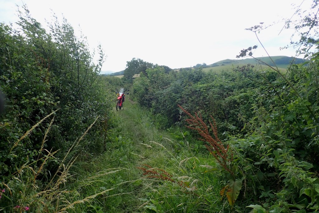
Maiden Newton to Lyme – only 36 miles. No biggie then…I set off along the same trail through Sares Wood to Tolpuddle to make sure I didn’t make it up.That’s more like it! I feel at home now.I get in a tangle around Dorchester and then miss the road to Maiden Newton; I find I often mess up the nav when I half know the way; a little knowledge is a dangerous thing, grasshopper. To make amends I consider this shortcut down a hillside to Maiden, but at a gate I re-scrutinise the Garmin’s OS map and it’s only a Bridleway, which I confirm later on the county DM. Can’t be going there.Back on the GWT, I turn onto my first trail, sorry – unclassified road. I’ve made the Garmin’s GWT tracklog green to make it easier to see.I can do this!I think ‘Public Route’ may be a kind of ORPA. Back on the asphalt, my front tyre seems to be making a lot of noise. It was 19psi this morning, not a pressure I run. There’s a lot of debris down the middle of these hedgebound, single track lanes. Have I got a slow puncture on the presumably crappy OEM IRC tyre? (Yes). I’ll top up at the next servo.Many roads lead to Hooke. I wonder if houses in Poorton are cheaper than Powerstock? Hooke in the Domesday BookeHooke’s dinky, red sandstone church of St Giles. ‘Only’ 600 years old.Unsuitable you say? Hold my beer!I still find it hard to believe I’m allowed to actually ride ‘footpaths’ like this. I am what I am and I’m one of the sheeple ;-)I emerge by a field where hidden ruts alongside a 2000-volt electric fence help concentrate the mind.First gate of the day – good for the abs.Here comes that weather.I pass through Beaminster town with half an eye out for an airline, before burrowing back into the undergrowth like a motorised hedgehog. Never seen a BOAT sign before. Encouraging.Oh dear, what’s up now?I’m knocked back by a couple of limestone rock steps on a stoney slope. It would have needed quite a launch plus some artful finesse – not a combo me or the 300L share at this time, thanks for asking. Alone, a bad fall could end… badly. The TRF call this lane an ‘old favourite’. Not me.I don’t even think about it and walk the bike up in 1st, but it gets jammed on the bigger step, then the chain comes off. A bigger tyre with less air might have clawed its way up. Never had a chain derail on a moto but at least it’s not broken nor has cracked the crankcase (had that on a KLX once – ruined engine). Luckily, this time I left home with tools. I drag it back down – this is where old-school tubularrear racks pay off. I prise out the very slack chain which easily rolls back onto the sprocket. Did the derailing stretch it so much? Along with my imminent flat tyre and the darkening skies, I’m a bit unnerved.Nearby there’s evidence that fourbies struggle here too. This lane – Meerhay or Mintern’s Hill (50.825716, -2.733489) throws me, but there’s no mention of it online. Even coming downhill I’d think twice, but it must be just me and my age. Returning to Beaminster, a delivery driver stops and asks about getting through. He knows about the BOAT and meanwhile, points me to a car garage in town.I pop in for a shot of air, just as the clouds unzip, let loose and shake off. Aired up to 30psi to get me home, I pretend to fiddle with the GPS until the downpour passes.I’m aiming to rejoin the GWT as it heads down to Bridport. At a crossroads I stop and tighten the chain with my new Rally Raid tool. It took 2.5 full turns of the nut. WTF? It wasn’t hanging off after a wash and lube two days ago. Is the Regina suddenly shot at just 1500 miles on this 28-hp donkey? Very odd, but better to know now than on Jebel Saro.Beferned phone box. A sign of the times.Beferned 300L. Not more of the psychedelic type, I hope.Unsuitable …… for XXL hay tractors
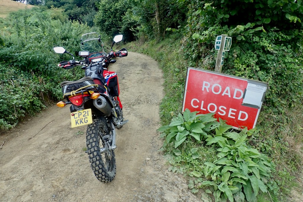
My mojo has rebounded so I continue west out of Bridport towards Lyme on the GWT. North of Symondsbury I come across a ‘closed road’ sign. Shame, it’s a nice track – Hell Lane in fact, as featured in ABR magazine a few years back.
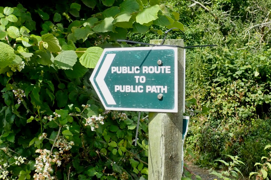
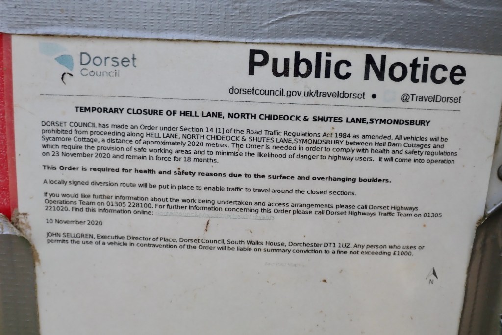
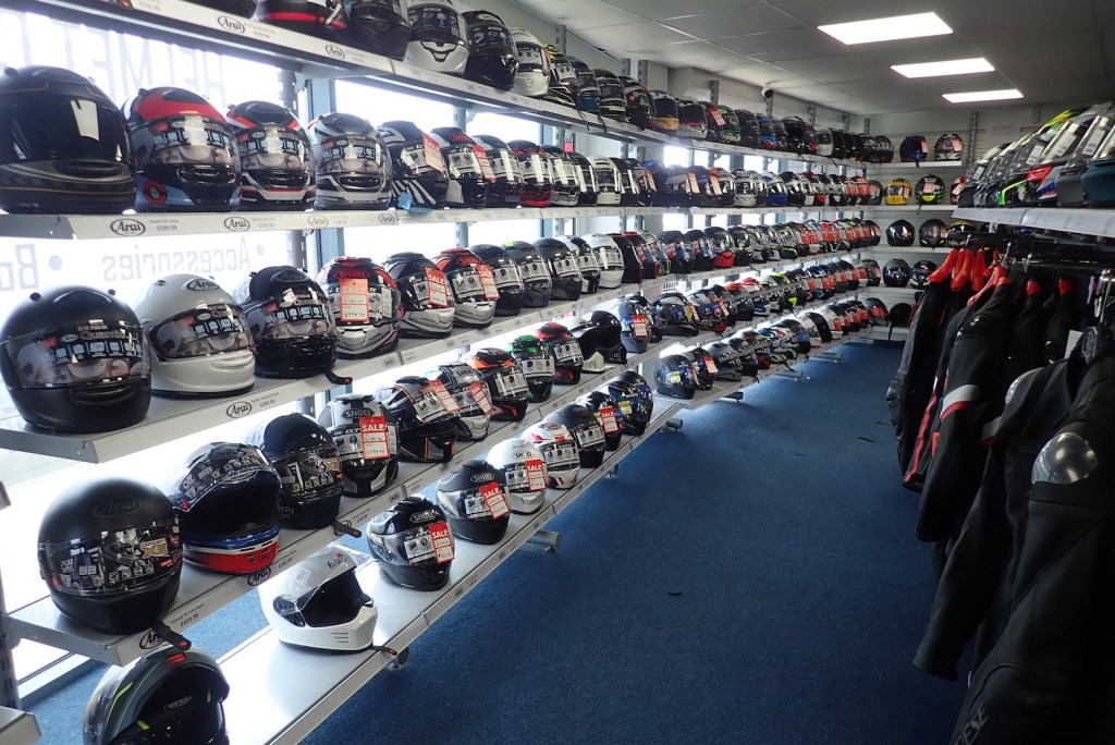
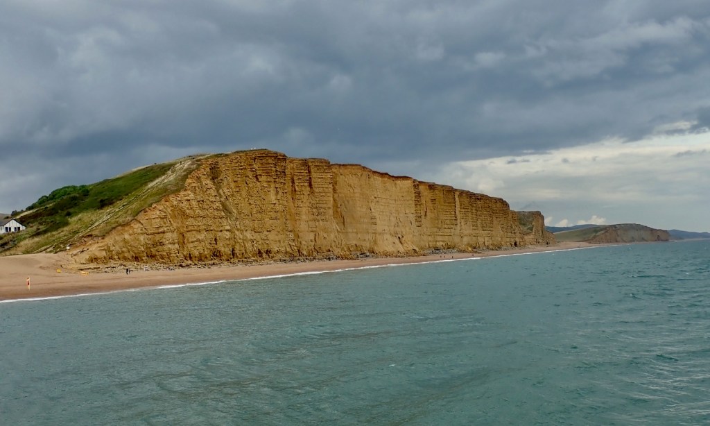
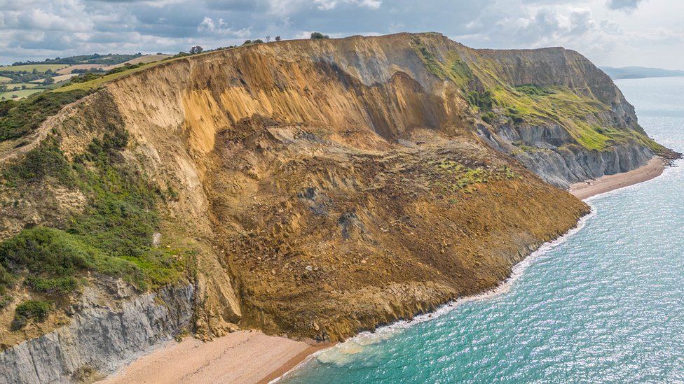
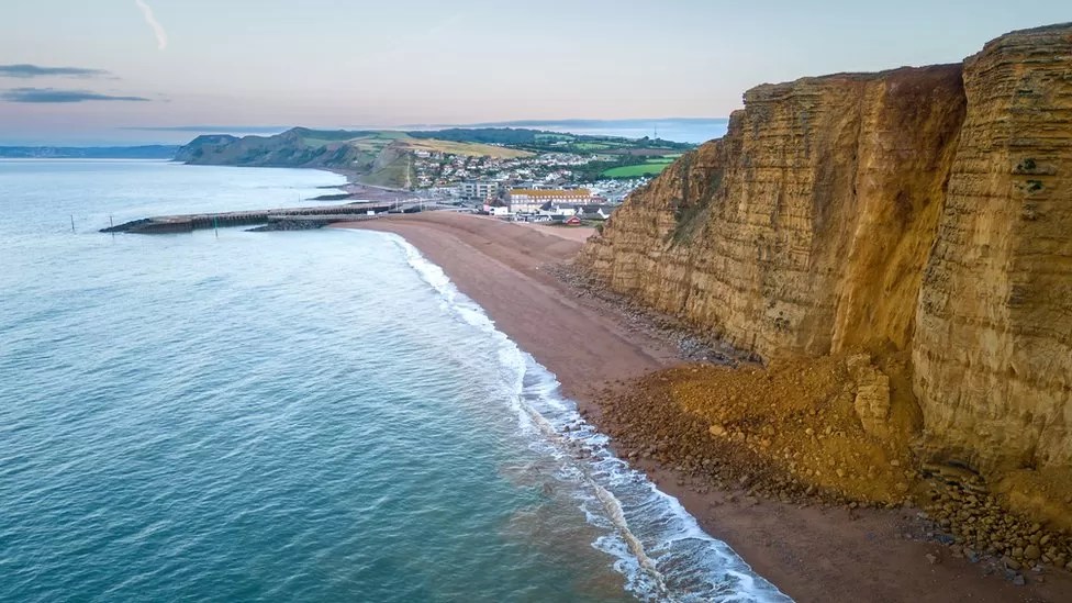
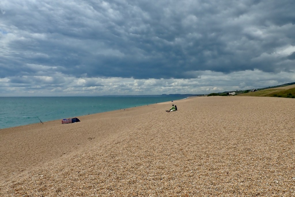
It’s a ‘public route to a public path’ which must mean something legally.Had I read the TRO more closely I’d have seen it expired last year. Specsavers, I know, but ditch the red sign already! I try a way round to the north but I’m blundering around. This isn’t a moto RoW.The chain thing and all the rest has worn me out so I scoot south to the seaside for a seafood snack by the seashore. Let’s try West Bay. I was hoping for calamari at a quaint 1770s cobbles and thatch Smugglers Inn – I get 1970s bucket & spade in batter with chips.Little West Bay seems to be a bikers’ hang out.Heck, they even have a Helmet City! The sweet smell of creaking leather…Recognise that cliff? Yep it’s ‘Broadchurch’. Remember all the hype over that show?That night a nearby cliff slid down and made the news. That would have been a heck of a reverse tsunami.A couple of weeks later, after a lot of rain, West Bay / ‘Broadchurch’ cliff, itself had a big rockfall.Lyme in the far distance, one for next time.I head home on backroads. It’s Chesil Beach! Never been there neither, here’s my chance. Gravel; large amounts. ‘The origin of the beach is a matter for scientific speculation‘ says an info board.Bit harsh.Backroading homewards, near TE Lawrence’s grave, two roads diverged in a wood and I took the ORPA less traveled by. And that has made all the difference; I got home 4 minutes earlier. I’ve done 100 miles and I am now quite tired.
After thoughts on L I’m getting a feel for the 300L off-road. No, really! The stock gearing feels spot on for this sort of riding; a full load might change that. But the fuelling is a bit on-offy in lower gears; good for engine breaking. I recall the WR250R (same hp) had the same issue and there were alternative, slow-action throttles or some such available. It’s an efi thing. The stock tyres are good but I don’t think will prove very durable; iirc my CRF250L IRC rear didn’t even make 3000 miles in SW USA. As said, the Rally Raid suspension seems dialled in, or if not it won’t be hard to do so. I notice the throttle cables jam solid on full left lock as a result of the taller Renthals; to be expected for a stoop-free standing stance – without risers! Easy to fix or not that important. On the road it zips up to an indicated 60 – going faster needs a big yank on the handle; it’s a 286cc after all. I do wonder about this 19er front business, but trying is knowing. In return for on-road stability I hope the steering won’t get too sluggish on the trails. I have a spare front hub which I was going to lace to an unbranded 19-er and flog, but I think now I’ll fit an SM Pro 21 MT (tubeless; and at £170, £50 cheaper than an Excel) instead. Then I’ll have a three-wheel full tubeless set up: 17 + 21/19. The 2.15 SM Pro MT is half an inch wider than the stock 1.60 x 21 which will mean a heavier, wider tyre that won’t help trail agility, but might aid faster, bend swinging stability and wear.
I’m still not fully satisfied with my seat bodge. It has a dip in the front so it’s either fully sat back (OK for high speed) or perched up front. This may be where they shaved it down to make it lower. It would be nice to have a fully flat seat to slide around on to spread the pain. A mate sent me a pic of his normal L seat (left) and there is definitely more meat to it; he’s my weight and finds it fine. I could’ve got mine rebuilt locally in leopard skin metal flake, but decided to simply buy a new black OEM 2023 seat from Partzilla discounted to $105 (30% cheaper than a red 2021 seat). Add shipping and UK tax and that’ll be about £150. I ought to get most of that back for my low seat.
This package caught my eye the other day: a trans-state, mostly dirt road adventure across Utah, comprising of a dedicated paper map, an hour long dvd and track logs on the Utah BDR webpage to put it all together.
With the Colorado river cutting through the Canyonlands on its way to the Grand Canyon, southern Utah must be one of the most photogenic places on earth. It’s a wilderness spectacle I’ve visited a few times, and one that’s exemplified by the iconic buttes of Monument Valley (or is it Valley of the Gods, nearby?) which featured on the cover of an earlier edition of AMH in the late 90s.
The Backcountry Discovery Route project seems to have been cooked by Touratech USA’sPaul Guillien, describing the idea as ‘a community based effort dedicated to establishing and preserving off-highway routes for adventure motorcycle and dual-sport travel’. It recces, plots and describes itineraries on public roads across the wild corners of the western states. They’ve done Washington in Touratech USA’s back yard. Here is Utah with the Colorado BDR out in February 2013 and other western states like Arizona, Oregon and Montana in the pipeline.
It’s a concept which reminds me of what may well have proved to be the over-ambitious Great Western Trail, itself parallel to the Can to Mex Great Divide Route (GDR) mapped by the Adventure Cycling Association. They may not have planned it that way, but much of the GDR happens to be usable by road legal vehicles and was featured in earlier editions of AMH.
I’ve always thought the GWT or GDR were much more inspiring rides than the better known Trans Am Trail. Surely the mountains, deserts and history of the American west trounce the interminable prairies and agri monoculture east of the Rockies?
Years ago I had an idea to make a guidebook to the region, but knew it would need an online, track log and video element which was all beyond me at the time. So it’s great to see someone with the resources of Touratech and the associated BDR supporters taking on the task, state by state, to map and log the sort of multi-day mini-adventures that adv bikes are made for. And if Touratech, Klim and whoever else supports the project sell a bit more stuff to wannabe BDRoutards, then good luck to them.
The DVD The film was shot over a nine-day period as eight riders followed the trail from the Arizona border near Monument Valley up to Bear Lake which spills into Idaho. In the credits I recognised the name Stirling Noren who made a great film for Helge Petersen in Iceland a few years ago, though it seems his role with this production is merely as distributor. As you’ll read below, that’s a shame.
I don’t watch many dvds these days – does anyone? – but what immediately struck me having just watched Richard Grant’s sublime American Nomads doc on TV was the comparative ropiness of standard definition. How quickly we’ve got used to HD, but AFAIK you can’t make old tech dvds in HD unless they’re Blue-Ray. And although the original footage was almost certainly shot in HD, only the online trailers can depict the benefits of HD’s much greater resolution, as you can see here.
And so we set off to follow the octet of Routards aboard well-laden BMWs and KTMs, none smaller than an F800GS. It’s great to see big adv bikes actually being put through the paces which their marketing claims they excel at; fully loaded for days riding the dirt highways of the American west. The film was presumably shot in high summer but the weather was not so summery, or maybe that’s normal for Utah which, despite its association with red rock desert canyons, is actually quite high. And with the shooting understandably taking place in the mid part of the day when desert light can be harsh, I missed what I knew to be the golden glow of Utah’s desert scapes.
So when you consider they’re riding though some of the planet’s most striking vistas I have to say I found the film a little disappointing for its hour’s length. Riding for several days is repetitive of course, but a little creativity in the shooting would have lessened this impression. I also thought the drama got a little overcooked at times, not helped by the occasionally portentous ‘my god, will we make it?’ score. I know from my own experience that getting a good score can be one of the most challenging aspects of editing a film, but when you get it right it can hugely improve a film’s watchability. The UTBDR film makes all this a little more difficult by dropping the ambient background soundtrack, except when the riders are doing their ‘P2C’ camera chats. This may have been a wind noise issue (a Jeep support vehicle was used), but you do miss the growl of the big twins hauling along the trail while the wind whistles across the mesas.
This film was directed, scored and edited by Curbsyde Production’s Flora and Joe Lloyd who seem to have developed a certain look of long, low shots in slo-mo. These work well in demonstrating the pounding suspension of the heavyweight adv bikes, but alternative views on the action would have made the dvd more involving to the target audience. We’re riding motorcycles here, not watching lions stalk their prey on the Serengeti. More on-bike or alongside-bike PoVs could have been mixed in with the long shots to emphasise the dynamism of big bikes rolling through the landscape. There are a couple of these and from one shot (right) there’s what looks like a Lumix FT mounted on the bars – a great little camera which I now prefer over my recently sold GoPro. With this sort of hardware and some RAM mounts it’s not difficult to film anything moving from any angle.
I suspect the tight schedule and at times poor weather made all this too difficult. No one ever quite manages to shoot the film they hoped. Many of the better slo-mo shots are used over and over again in the hour-long film with what feels like 90% taken locked off on a trackside tripod with the bikes passing through the frame. That’s the stock shot in films of this type and works well in a short, youtube promo vid but as I said, over an hour there could have been more creative shooting: high on poles, low on the ground, anywhere you like on the bike or alongside it. I may have got the wrong end of the stick, but Flora Lloyd didn’t make the best of this opportunity.
Film the journey not the ride The film sticks solely to the trail. Let’s see the mud-spalttered posse rolling in to a Ma and Pa fuel station, cutting loose in a cantina in Moab, or chatting with locals. Film the journey not the ride, with less of the straight-backed campsite asides about the awesome day’s ride – we know, we just watched it. I think the group was too big to be able to achieve this, but perhaps the many necessary supporters involved in the project wanted to be sure they got their share of face time in the finished product.
No one ever appears tired, hungry, fed-up or even dirty, heavily clad as they are in pristine Touratech or Kilm apparel. The cramming home of the corporate sponsors’ message gets a bit disengaging – at least to a UK viewer. Possibly in the US – where they’ve just spent $2bn promoting an election – this sort of hard sell is normal.
You’ve got to see it all to know it all of course, but once the riding is over many viewers would have wanted to see something like I tagged onto the end of my first moto video shot in western Canada in 2001: the group sat around discussing how their gear and their huge bikes performed following their 900-mile backroad adventure. Perhaps that all features on some blog somewhere, but if it exists you’d think it’d be linked off the BDR website.
The BDR is not all dirt either, and so I think it would have be fun and no less ‘on message’ to see the big twins carving up a bit of Utah’s blacktop from time to time. The film has some great moments and there are some slick time lapse shots too, especially at night, that seem to be over too quickly. But all up it didn’t make the UTBDR look half as good as I bet it is, given the huge task of herding eight trail weary cats to try and grab a killer shot.
Clips like ‘I don’t know much about Newspaper Rock [Indian petroglyphs, Canyonlands] but that is where we are‘ and ‘… where we saw some great… err, I believe Anasazi… err, petroglyphs on the wall?’ would have been better left on the cutting room floor. If you’re going to talk about that sort of stuff, know what your talking about, otherwise it comes across as a lame token filler. Luckily the following voiceover claws back some credibility. The bonus material includes only adverts from the sponsors and supporters, plus some stills from the mission’s photographer, Jonathan Beck. You’ll get no goofy outtakes here!
It’s easy to be sniffy about paying for dvds these days when great stuff like the Nomads doc above can be found online for free. We’ve all become mini Spielbergs too, spotting flawed filming even if we couldn’t do any better. I recognised myself a few years ago that the effort required to shoot worthwhile footage and then assemble it into a sellable film takes up much more time and resources than you’re ever likely to earn back. Although the vid was disappointing, there can be no better format in vividly giving you an idea of what to expect on the trail, short of slapping it on youtube. As it is they give away the GPS tracklogs for free, so I don’t resent paying for the vid. Exploring southern Utah on a bike, including the Lockhart Basin, Onion Creek and the nearby White Rim Trail are certainly something I hope to have a crack at some time soon (I did: here and here).
The Butler Map Butler’s double sided map of the UTBDR covers the whole state at a scale of 1:714,000 which for some reason adds up to 11.2 miles to an inch (US map scales have always baffled me). The map measures just over 3 feet by just over 2 feet and is printed on tough plastic paper. As I’ve found in Morocco, this is the way to go with maps that’ll get rough use, specially on a moto. You can use such a map hard and it won’t fall apart like a Michelin.
Clearly you’re expected to rely on the track logs downloaded from the UTBDT website; the Butler map probably won’t be enough to navigate with, but it gives you the big picture that a GPS screen never can. If you’re a heretic with something against satnavs (or your unit packs up…) you could try printing off Google maps, more accurate Utah topo GPS maps (left, with the UTBDR displayed using Garmin BaseCamp) or drawing the trail along something like a large-scale Delorme or Benchmark atlas (right) which goes down to 4 miles to an inch (1:250k) and provides a whole lot of guidebook-like info too, even if they are too bulky to sit on a tank like a Butler map. More on this below.
The map breaks the 870-mile trans-Utah route into six sections, although it’s not clear what separates these sections – it doesn’t seem to be obvious places like reprovisioning points. Nor could I find exactly how many miles are dirt, dirt options or sealed roads, all of which help get a measure of the task ahead. Another thing that would be useful are incremental mileage markers along the trail, starting at zero in Goulding and appearing at say, at every key junction such as Valley of the Gods start on US 163 (28.6m) and then another at where VotG Road joins UT 261 below Moki Dugway (54.1m), meaning you can work out that VotG dirt road between those two points is about 26 miles, or an hour or two’s riding.
Another thing that’s immediately apparent is the lack of a lat-long grid, something I go on about with Morocco maps used for similar sort of riding adventures. The 1:714k-scale may be a bit small for this, but with a lat-long grid and a back up GPS (like a smart phone) you can pinpoint your position should your satnav go up the onion creek. Until there are helpful BDR signposts at each junction, this ability could help you avoid making a mistake by following the wrong track. Along the Route there seem to be several alternative dirt trails and countless junctions where a long-lat grid would be a useful navigation aid.
On the reverse side of the map you get a very neat elevation profile using the full width of the paper (although they miss out depicting the alternative routes which could mean the difference between going high or staying low). There are also a dozen or so insets of what you presume are tricky unsealed sections enlarged to 4 miles to an inch and which seem to use the same base map and scale as the Benchmark atlas mentioned above. I feel they could have dumped the rather lacklustre moto-action photos which haven’t printed very well on the plastic paper, and made those map insets either larger scale, or have them cover a larger area. Maybe I’m old fashioned, but on a ride I’m used to getting involved with the nav and tracking my route on a map, rather than relying solely on a line on a satnav screen. Out here a good paper map is vital.
A handful of QR codes lead you to online videos of each section, or are promotional/commercial links. You’d think it would be handy to have say, accommodation and eating options in the few towns along the route, even if it was just a third party site such as a local tourist board. One QR indicates gas, food and lodging, another links to ‘route conditions’, but there’s no indication of a url so if you don’t have a QR-reading smart phone you’re in the dark. There’s no indication on the UTBDR website what these links might be.
You have to congratulate Touratech, Butler and all the rest for coming up with a great concept that will be a shot in the arm for dirt road exploring in the western US: ready-made, bite-sized, week-long adventures that are guaranteed to get you riding your machine into the heart of the wilderness without inadvertently ending up at the end of a rancher’s shotgun, a dead end or in a ranger’s citation. Despite my criticisms the dvd and map are well worth $40 as it’s hard to think anyone’s going to make much on this whole deal when all the work is done – the value will be mostly promotional to all concerned. Yes you could pick over the web for days to get this all for free, but like a good guidebook, sometimes it’s just easier to pay up a little to gain a lot of inspiration from someone else’s hard work. I’m looking forward to the rest of the BDT series.


 caths the action")


